


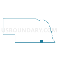
Davenport-Carleton Precinct, Thayer County, Nebraska
About
Outline

Summary
| Unique Area Identifier | 613977 |
| Name | Davenport-Carleton Precinct |
| County | Thayer County |
| State | Nebraska |
| Area (square miles) | 87.49 |
| Land Area (square miles) | 87.40 |
| Water Area (square miles) | 0.08 |
| % of Land Area | 99.91 |
| % of Water Area | 0.09 |
| Latitude of the Internal Point | 40.27091560 |
| Longtitude of the Internal Point | -97.74131250 |
Maps


Graphs
Select a template below for downloading or customizing gragh for Davenport-Carleton Precinct, Thayer County, Nebraska


Neighbors
Neighoring Voting District (by Name) Neighboring Voting District on the Map
- #110 Precinct, Fillmore County, NE
- Belvidere-Bruning Precinct, Thayer County, NE
- Deshler Precinct, Thayer County, NE
- Elk Precinct, Nuckolls County, NE
- Hebron North Precinct, Thayer County, NE
Top 10 Neighboring County Subdivision (by Population) Neighboring County Subdivision on the Map
- Deshler precinct, Thayer County, NE (981)
- Davenport precinct, Thayer County, NE (677)
- Bryant township, Fillmore County, NE (434)
- Elk precinct, Nuckolls County, NE (325)
- Hamilton township, Fillmore County, NE (126)
Top 10 Neighboring Place (by Population) Neighboring Place on the Map
Top 10 Neighboring Unified School District (by Population) Neighboring Unified School District on the Map
- Thayer Central Community Schools, NE (2,761)
- Deshler Public Schools, NE (1,402)
- Bruning-Davenport Unified School System, NE (1,372)
- Shickley Public Schools, NE (736)
Top 10 Neighboring State Legislative District Upper Chamber (by Population) Neighboring State Legislative District Upper Chamber on the Map
Top 10 Neighboring 111th Congressional District (by Population) Neighboring 111th Congressional District on the Map
Top 10 Neighboring Census Tract (by Population) Neighboring Census Tract on the Map
- Census Tract 917, Fillmore County, NE (3,571)
- Census Tract 9631, Thayer County, NE (2,771)
- Census Tract 9600, Nuckolls County, NE (2,394)